Typhoon Hagibis strikes the Japanese Archipelago: What happened behind the scenes as Japan’s capital narrowly escaped becoming submerged

The Arakawa River went above the dangerous water level at multiple points.
Although Typhoon Hagibis (Typhoon 19) caused enormous damage to many parts of Japan in 2019, Tokyo saw no dikes collapse and escaped serious flood damage. We investigated the truth of what occurred behind the scenes during the Japanese capital’s escape from submersion, based on the reports of local government officials and flood control facilities.
In October 2019, Typhoon Hagibis brought record rainfall, mainly to Shizuoka Prefecture, the Kanto and Koshinetsu regions and the Tohoku region. Special heavy rain warnings were issued for a total of 13 prefectures, including Tokyo, with dikes breaking at 140 locations along 71 rivers (as of 6:00 AM on November 8), and many parts of the country were seriously damaged, including flooding. Even in this situation, although the levels of many rivers in Tokyo rose higher than usual, the dikes escaped damage. We investigated the truth of what happened behind the scenes to enable the capital to escape submersion.
30% of the rainfall in the river basin was discharged through the discharge channel
Looking back on the desperate situation he experienced when Typhoon Hagibis struck Japan on October 12, Hasegawa Yutaka, director of the Crisis-Management Division at the Katsushika City Office in Tokyo, said, “The water rose above the dangerous water level in the upper reaches of the Nakagawa River and the Ayase River, which run through Katsushika City, and we were in a very bad situation. If the two rivers had not discharged through the discharge channel, we might have seen a large-scale flood.” The hazard map of Katsushika City shows that if these rivers overflow, almost the entire western half of the city could flood. In some places, the water may even rise above the second stories of some buildings. The overflow of these two rivers is a matter of life and death for Katsushika City.

Source: Created by Discuss Japan based on data from the Katsushika City http://www.city.katsushika.lg.jp/_res/projects/default_project/_page_/001/018/693/hmbig3-4.pdf
Discharges into a large river through multiple upstream basins prevented the Nakagawa and Ayase rivers from overflowing after Typhoon Hagibis made landfall. According to the Edogawa River Office of the Ministry of Land, Infrastructure and Transport (MLIT), the Metropolitan Area Outer Underground Discharge Channel and the Misato basin helped reduce the water level of the Nakagawa River by 30 centimeters and reduced the time spent above the dangerous water level by 23 hours. In addition, the Ayase River Basin helped reduce the water level of the Ayase River by 78 centimeters and reduce the time spent over the flood dangerous water level by 24 hours. Without these facilities, the Ayase River would also have gone over the planned high water level (see Figure).

Chibana Takeyoshi, an associate professor at the Graduate School of Engineering of the University of Tokyo, notes how effectively the discharge channels (and basins) worked, saying, “The reduction of the time spent over the dangerous water level led to an alleviation of the danger of a crisis and the shortening of the time period when people needed to be cautious of the typhoon, which resulted in the lifting of an evacuation advisory more quickly.”

The Metropolitan Area Outer Underground Discharge Channel discharged a volume of water nine times larger than the Tokyo Dome through its underground spaces.
Called the Underground Palace, the Metropolitan Area Outer Underground Discharge Channel in Kasukabe City in Saitama Prefecture is one of the world’s largest discharge channels, completed in 2006 at a cost of about 230 billion yen. It discharges water from five rivers, including the Nakagawa River, through a 6.3 km discharge channel 50 meters below ground.
The Metropolitan Area Outer Underground Discharge Channel began discharging water at 11:30 AM on October 12 and discharged about 115 billion cubic meters of water (about nine times the volume of the Tokyo Dome) to the Edogawa River by 3:13 PM on October 15, when the discharge pumps finished operating. This was the largest discharge since the heavy rains of Typhoon Etau (Typhoon 18) in 2015, which caused the Kinugawa River to overflow.
The water of the Nakagawa River was discharged to the Edogawa River in the Misato basin in the lower reaches of the Outer Underground Discharge Channel and the amount of water discharged was nearly three times the amount discharged by auxiliary discharge channels. In addition, water from the Ayase River was discharged to the Nakagawa River within the Ayase River basin and then was discharged to the Edogawa River in the Misato basin and also to the Arakawa River by pumping from the Ayase Pumping Station downstream. A little less than 30% of the rainfall in the Nakagawa and Ayase River basins was discharged to places outside the basins through these multiple discharge channels.
These discharge channels worked so effectively that the capital narrowly escaped flood damage. But Iwasaki Kazuo, deputy director of the Edogawa River Office, said with a feeling of impending crisis, “The slopes in the Nakagawa and Ayase River basins are so gentle that water easily collects. In addition, urban development is so rapid in the area that water cannot easily penetrate the ground and easily run into the rivers. If there had been localized rainfall in the river basins, the rivers might have flooded. I don’t want to think about this kind of worst case scenario. But given frequent recent examples of localized heavy rainfall, I think that the possibility of such an event is growing.”
The Arakawa First Regulating Reservoir recorded a record volume of water
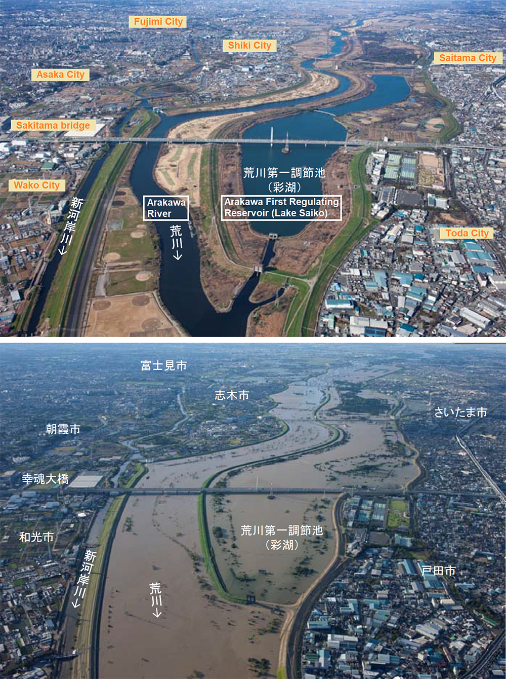
Source: Created by Discuss Japan based on the website of the Kanto Regional Development Bureau, Ministry of Land, Infrastructure and Transport https://www.ktr.mlit.go.jp/ktr_content/content/000760776.pdf
Retention basins distributed across the country, such as the Arakawa First Regulating Reservoir, the Kanda River/Ring Road No. 7 Underground Regulating Reservoir and the Tsurumi River Multipurpose Retarding Basin, have been shown to work effectively, together with the discharge channels. One of these, the Arakawa First Regulating Reservoir completed in 2003 after 34 years of construction, collected approximately 350 billion cubic meters of water (28 times the volume of the Toyo Dome), 90% of the amount of its capacity. This is the largest quantity of water ever stored in the Arakawa First Regulating Reservoir.
The Arakawa First Regulating Reservoir is situated in the middle of the Arakawa River basin and is usually used as a baseball park or a public park. But if the water level of the Arakawa River rises above the overflow bank between the river and the Regulating Reservoir, the river water will automatically flow into the retention basin. If you close the drainage gate at the exit of the basin, water will collect. Flood control measures using the reservoir were conducted from around 11:35 PM on October 12 to around 10:00 AM on October 13.

Drain gate of the Arakawa First Regulating Reservoir
“The water level of the Arakawa River rose significantly. It was the worst crisis situation I have seen. What would have happened if it had not been for the Arakawa First Regulating Reservoir?” said Honda Yoshinari, general director of the Disaster Prevention and Crisis Management Division, Edogawa City Office.
Edogawa City, located in the lowest reaches of the Arakawa River, watches water levels closely at the Kumagaya, Jisuibashi aqueduct bridge and the upper Iwabuchi Watergates. The water levels reached dangerous levels at Kumagaya around 4:00 PM on October 12, and at Jisuibashi around 1:50 AM on October 13, with record high water levels later being recorded at both of the gates.
Currently, the second and third regulating reservoirs are being developed just next to the Arakawa First Regulating Reservoir. Construction work will last until 2030 with the completed regulating reservoirs to have a capacity about 1.3 times that of the First Regulating Reservoir.
Shiroyama Dam’s decision during an emergency discharge
The Sagamigawa River runs across the central part of Kanagawa Prefecture. This river is known as an important irrigation river that provides water to 60% of the prefecture’s residents. In that river as well, dams were used to control the damage that Typhoon Hagibis could have caused.
At 9:28 PM on October 12, a telephone rang at the headquarters for disaster control in Atsugi City in Kanagawa Prefecture, located in the middle reaches of the Sagamigawa River. The caller was an official in charge of Shiroyama Dam (Sagami City), managed and maintained by the prefecture. The official called to inform that the Shiroyama Dam upstream would be starting an emergency discharge in two minutes.
Since that morning, the Shiroyama Dam had been controlling flooding by discharging less water than was flowing in, collecting water in its reservoir. An emergency discharge is intended to prevent the water level from rising by increasing the discharge of water before the water that has collected in the dam’s reservoir overflows and damages the facilities. A discharge of water greater than its inflow was not going to be conducted, but the water level downstream could rise above previous levels.

A large amount of driftwood created by Typhoon Hagibis was still floating in the Shiroyama Dam reservoir on 20 October.
Source: t-eight / PIXTA
Initially, the official in charge of the dam informed the local governments along the river that the emergency discharge would start at 5:00 PM. The rain slowed down and the emergency discharge was at first postponed until 10:00 PM. But then a larger quantity of water than predicted flowed into the dam, leading dam operators to start the emergency discharge suddenly at 9:30 PM.
Regarding this emergency discharge, Takahashi Katsumi, subsection chief of the Crisis Management Division of the Atsugi City Mayor’s Office, said that things were in confusion because flood prevention teams and fire services had begun to work along the Sagamigawa River after 9:00 PM, helping local residents evacuate. At that time the water level had already risen as much as 1 m above the dangerous water level at the Kamiechi Water Level Observation Station on the Sagamigawa River. At 11:00 PM, one and a half hours after the start of the discharge, the water level rose to 1.6 m over the dangerous water level. Considering the rise of the downstream water level, Shiroyama Dam made the decision to reduce the discharge of water, despite the emergency discharge being underway. They brought the dam’s reservoir to within 12 centimeters of full capacity to prevent a further rise in the water level.
Miyagase Dam received an average of 780 millimeters of heavy rain in the basin
Miyagase Dam, situated similarly to Shiroyama Dam on the upper reaches of the Sagamigawa River, had prepared for rainfall the day before Typhoon Hagibis arrived. Coordinating with those involved in irrigation in the area, they conducted a prior flow, lowering the reservoir’s water level by discharging irrigation water and securing a capacity of 50 million cubic meters of water. As a result, Miyagase Dam was able to control flooding by lowering the water level of the Nakatsugawa River, which empties into the Sagamigawa River, 2 m. Wakamatsu Akio, director of the Regional Water Management Division of the Miyagase Dam Operation & Management Office, spoke about how tense things were at that time, saying, “A simple calculation showed that we only had the capacity for another eight million cubic meters of water. If the heavy rain had lasted for another one or two hours, Miyagase Dam also would have been forced into an emergency discharge.”
According to MLIT, the retention of water by the two dams lowered the water level at 12:00 AM on October 13, which reached a record high, 1.1 meters over the previous record, near Sagami-Ohashi Bridge in Kanagawa Prefecture. Some media reports criticized the Shiroyama Dam for not having conducted a prior flow. Regarding the operation of the two dams, however, Professor Sumi Tetsuya at Kyoto University’s Disaster Prevention Research Institute, said as follows:
“It was appropriate in terms of the structure of Shiroyama Dam that they did not conduct a prior flow. The criticism from some media outlets is irrelevant. Even when the maximum inflow of water was recorded, Shiroyama Dam controlled its discharge of water below that and successfully reduced the inflow of water to the Sagamigawa River. Miyagase Dam gathered nearly 800 millimeters of rainfall in its basin. These two dams made an enormous contribution. An estimate by Kyoto University shows that the two dams reduced the water’s flow from about 70 million m3/s of flood at its peak to about 45 million m3/s. If it had not been for the two dams, the local residents living along the river would have likely been seriously damaged.”
The development of flood control facilities is limited
Because the discharge channels (basins), regulating reservoirs, and dams worked so effectively the center of Tokyo narrowly escaped massive damage. But this does not give us a sense of security. The heavy rains of Typhoon Hagibis were of such short duration that the effects could be controlled by existing facilities. But if the rainfall had continued for longer, the outcome might have been different.
Currently, each river is being developed according to an independent plan. But there are many challenges, such as obtaining land, construction costs and the time necessary to complete projects. The plans cannot be carried out easily.
Prof. Chibana said, “It is necessary to think about comprehensive flood control measures, about installing equipment for the temporary storage of rainwater in apartments and houses as well as river development. It is necessary to consider not only measures for the center of Tokyo, including floodwater discharge and water inside the lands protected by dikes, but also how to mitigate damage as much as possible, which is dependent on regional features, such as the asphalting of dikes to slow down their collapses as the rivers overflow them, especially in residential areas where the dikes cannot be widened. These developments cannot be carried out overnight. Intangible measures are important, such as the strengthening of local governments’ liaison systems for evacuations and ensuring that citizens always understand evacuation methods based on regional features.”
Translated from “WEDGE REPORT, Nihon retto wo osotta Taifu 19 go: Kamihitoe de fuseida ‘Shuto suibotsu’ no butaiura (Typhoon Hagibis strikes the Japanese Archipelago: What happened behind the scenes as Japan’s capital narrowly escaped becoming submerged),” Wedge, December 2019, pp. 40-44. (Courtesy of WEDGE Inc.) [March 2020]
Keywords
- Asano Yuki
- Sakurai Shun
- Wedge
- Typhoon Hagibis
- Typhoon 19
- Tokyo flood
- Katsushika City
- underground discharge channel
- Kasukabe City
- Arakawa First Regulating Reservoir
- reservoir
- Shiroyama Dam
- Miyagase Dam
- flood control
- evacuation
Related posts:
 Tokyo sunk: The day when Weathering with You becomes a reality
 Treasuring This Current Moment with My Family — TAKEKAWA Yoichi, Toy Importer
 A New Era of Michi-no-eki Takes Off! – Ever-evolving community hubs for local rejuvenation –
 Dialogue between Taiwan and Japan, the Bereaved Families of the Accident across the Ocean
 Politics and Harassment: Why Aren’t There More Female Assembly Members?